Palm Springs active transportation panel tackles bike safety on Ramon Road, maps, racks, and downtown access
The subcommittee heard from neighborhood groups, reviewed a revised bicycle map with safety concerns, and advanced plans for trailhead bike racks and sharrows on Sunny Dunes Road.
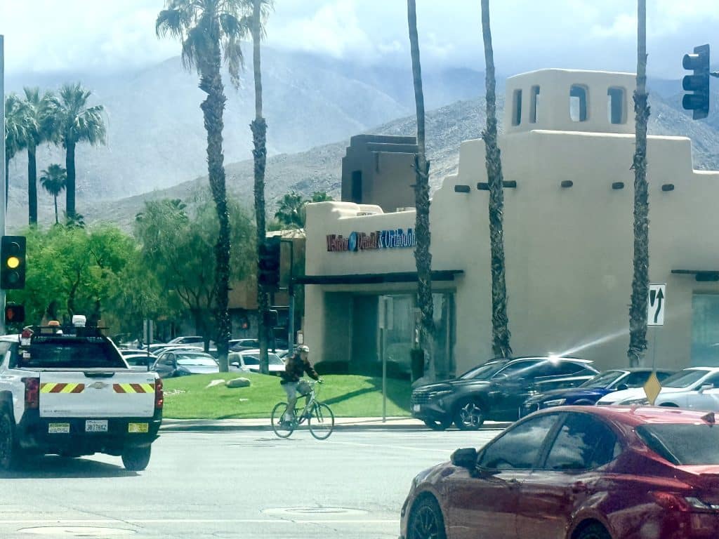
The Palm Springs Sustainability Commission Active Transportation Subcommittee met Monday, taking up a range of cycling and pedestrian issues from a contested one-mile stretch of Ramon Road to a crowd-sourced bike rack map and unresolved questions about safe routes through downtown.
Residents from the Warm Sands and Baristo neighborhoods appeared before the subcommittee to call for traffic calming, pedestrian improvements, and a CV Link connection along Ramon Road between Sunrise Way and Indian Canyon Drive — a stretch they say carries traffic dangers well out of proportion to its residential surroundings.
Local reporting and journalism you can count on.
Subscribe to The Palm Springs Post
Ned Barker, a member of a joint neighborhood committee between Baristo and Warm Sands formed to address traffic and pedestrian safety.
“Palm Springs has 250 miles of streets, mostly residential. Our one mile stretch of Ramon generated an injury accident rate between the 2023 and middle 2025 that is seven times the average rate for those 250 miles,” Barker said. “The need for significant improvements was clearly laid out more than 12 years ago in a plan created by the city and Agua Caliente Band of Cahuilla Indians.”
He outlined a set of improvements drawn from that plan including crosswalks with traffic signals at Calle El Segundo and Calle Amigos, updated medians with turn lanes and lighting, and a direct CV Link connection.
Assistant City Manager Flinn Fagg noted that the right-of-way along Ramon Road is not consistent, particularly on the south side, and recommended that the Agua Caliente tribe be included in any planning discussions.
“I kind of see it in three steps,” subcomittee Vice Chair and Warm Sands resident Fred Ross said, “A grant study to look at Ramon, then come up with some plans, and then a separate grant to come up with the funding.”
The subcommittee reached a general consensus that members would engage with neighborhood organizations and report back at a future meeting.
Bicycle map raises safety flags
Also connected to Ramon Road was a broader discussion about the accuracy of the city’s revised bicycle map, a draft of which was shared with the subcommittee for review.
Members flagged that Ramon Road between Indian Canyon Drive and Sunrise Way is classified on the map as a Class 3 bike route — a designation that indicates shared-lane markings, or sharrows — even though no such markings exist on the road.
“It leaves the city open to a lawsuit, to be honest,” one subcommittee member said. “Somebody has an accident and they’re riding it from the map on Ramon.”
Members also noted that some routes shown on the map follow sidewalks, and that the city’s municipal code prohibits cyclists from riding on sidewalks — creating a potential conflict between the map’s guidance and local law.
“[The route] switches from one side to the other, it has dangers when crossing driveways,” one member said. “It’s not clear that you should be riding on the sidewalks if you’re tourist. Are you thinking you’re supposed to ride in the 50 mph moving [car] traffic? That’s scary.”
Another member said they had pointed out issues with the map to the city, “They basically said, ‘We’ll do that later.’ I mean, there’s a lot of cleaning up on this map that has to happen.”
“If we’re rushing this map to get it out as quick as possible, let’s make it as safe as possible,” he said.
The subcommittee discussed adding clarifying language to the map to note where routes travel on sidewalks. A staff member said the map was slated for distribution to hotels and recommended the city move to annual updates as new bike infrastructure is built, rather than waiting several years between editions. Members were asked to submit any remaining revision comments directly to staff.
Separately, a city IT staffer told the subcommittee that she had uploaded the city’s bike route, lane, and path data to Google, but that the company offers no specific review timeline for bicycle infrastructure and no guarantee the data will be incorporated into Google Maps.
“Essentially, once we upload it and provide it to Google, it’s basically in their hands,” Megan Campe, a GIS analyst for the city said. “If they want it, they can take it.”
Trailhead bike racks
The subcommittee also advanced planning for bike rack installations at trailhead locations throughout the city, while grappling with limitations on how the city’s infrastructure data gets reflected on Google Maps.
City staff presented a right-of-way analysis of six trailhead locations where bike racks have been proposed, including sites near North Lykken Trailhead, South Lykken Trailhead on Mesquite Avenue and South Palm Canyon Drive, Murray Canyon near the horse stables at Murray Canyon Drive and Toledo Avenue.
A staff member noted that any installation near the South Lykken Trailhead entrance would require coordination with Agua Caliente tribal staff, even though the proposed rack location falls outside tribal land.
Fagg recommended committee members report to the full Sustainability Commission to determine how much funding has been set aside for bike racks, and engineering staff would develop general cost estimates for pads and installation.
A subcommittee member suggested adding a QR code to the printed bicycle map that would direct users to the crowd-sourced bike rack map the subcommittee has been building on Google Maps, allowing people to access current rack locations directly on their phones.
Downtown bike access on the horizon
Looking ahead to the subcommittee’s next meeting, members agreed to place downtown bicycle access on the agenda after one member raised concerns about the lack of protected bike infrastructure in the city’s core.
“The downtown core really has no safe bike infrastructure,” the committee member said. “The closest thing we’ve come to is Belardo Road as a potential bikeway, but it’s a lot of mixing in there with cars and a lot of car drivers don’t seem to have the awareness of the respect of combined use with bikes,” he said.
Members acknowledged that a protected two-way bike lane on Palm Canyon Drive is a longer-term goal requiring extensive outreach to businesses and property owners. The agenda item for the next meeting was described as an investigation into Belardo Road and Palm Canyon Drive as potential routes for improving downtown cycling access.
Author

Related Articles
Palm Springs seeks public input on next police chief
City officials say a new survey will help identify the leadership qualities residents want in a successor to retiring Police Chief Andy Mills.
Palm Springs Police Chief Andy Mills announces retirement effective Sept. 5
Mills described Palm Springs as the “crown jewel” of his career and said he and his wife, Cathy, plan to move to the Sacramento area to be closer to his mother.
Police release debrief video following fatal shooting of man brandishing knife
The video shows officers trying to de-escalate the situation and provide mental health services before a man armed with a knife left them no other option but to use deadly force.