
Planning Commission holds off on approving Tramview Heights plan for northern Palm Springs
Commissioners delayed a vote on the specific plan that could bring up to 1,594 homes and a long-sought grocery store site to the Desert Highland Gateway area. They will return to it Dec. 8.
The Palm Springs Planning Commission on Wednesday held off on approving an amendment to the specific plan covering more than 510 acres in and around Desert Highland Gateway Estates, which, if built out as planned, could transform housing and commercial opportunities in the neighborhood.
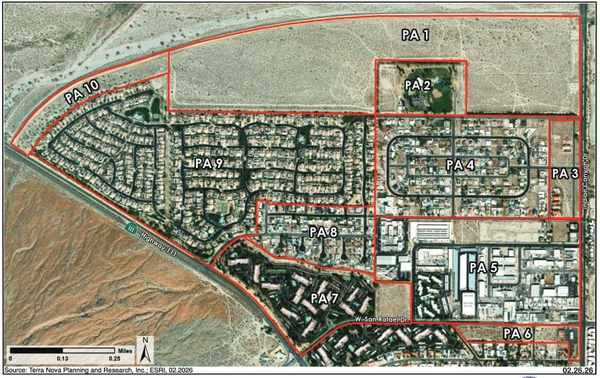
The Planning Commission continued its discussion of an amendment to the College Park Specific Plan, along with a related General Plan amendment and zone change for the area bounded by Highway 111 on the west, Indian Canyon Drive on the east, San Rafael Drive on the south and the Whitewater/Chino Creek flood control levee on the north.
Local reporting and journalism you can count on.
Subscribe to The Palm Springs Post
The amendment also renames the document and area from “College Park” to “Tramview Heights” and “provides updated vision, land uses, standards and implementation measures to allow for the revitalization and redevelopment of this portion of the City,” according to a city staff report.
Back in 2011, the city approved the College Park Specific Plan when College of the Desert (COD) had selected the northern portion of Tramview Heights for its West Valley campus.
The plan was developed “to not only support the campus’s development, but also the anticipated growth associated with new businesses and residential development that the College was expected to encourage through its curriculum and student generation,” according to a city staff report.
But that campus never came to fruition. Instead, COD ultimately chose the Palm Springs Mall site for its West Valley campus, which is currently under construction. In the 15 years since the original plan was approved, the area has seen very little development.
The amended Tramview Heights Specific Plan aims to spur more development in the area, especially housing, parks and commercial projects such as grocery stores.
The plan divides the large area into 10 planning areas. Some are already mostly developed, like Planning Area 7, which includes the Palm Springs Villas 2 development and an empty lot at the corner of West San Rafael Drive and McCarthy Road, or Planning Area 9, which encompasses the Mountain Gate community.
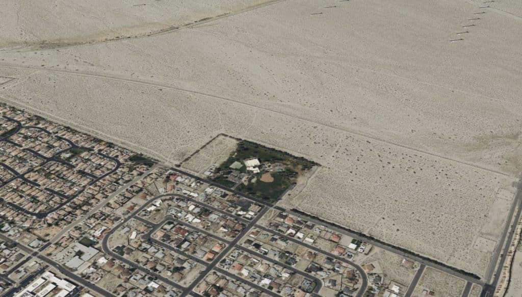
Others, like Planning Areas 1 and 10 along the northern edge of the specific plan, are currently undeveloped open desert land.
Residents have long called for a grocery store in the area, which has been considered a “food desert” because it lacks a grocery store and other basic neighborhood amenities.
The Desert Highland Gateway Estates Community Action Association is the city’s oldest neighborhood association. The neighborhood is where most of the city’s Black residents have lived since the 1960s, after families were forcibly removed from their homes in Section 14.
Cynthia Session, president of the association, called for the Planning Commission to approve the amended specific plan and maintain the proposed size of the designated commercial area.
“I was part of the Section 14 population that was forced to evacuate homes and move to the northern part of Palm Springs 50 years ago,” Session said. “Since that time, this community has been underserved and overlooked. Historically, the only projects the city has invested in here are those they did not want the tourists to see downtown like the Navigation Center.”
“Tramview Heights is the first opportunity we have seen to build something that is both beneficial to the community and a way to attract more visitors, residents and businesses to the area.”
All in all, the Tramview Heights Specific Plan could add 819 single-family units, 775 multi-family units, around 370,000 square feet of retail commercial space and around 32,700 square feet of industrial or commercial service businesses across the entire 510-acre plan area.
Most of that development would happen in Planning Area 1, the large swath of open desert on the northern edge of the specific plan that was once set aside for the COD campus.
Changing the specific plan and zoning for the area doesn’t necessarily mean all of that development will happen. It simply allows developers to propose projects that fit the new zoning on any particular site.
Nicole Sauviat Criste, a consultant working on the project for the city, estimated that the full build-out of the specific plan “is probably a 20-year timeline,” although demand for residential units means development of Planning Area 1, where much of the housing is concentrated, could happen much sooner.
The specific plan also includes several guiding principles for development in the area, informed by community input from neighborhood residents. These include:
- All residential projects must include pedestrian and bicycle connections if they are adjacent to such active transportation options.
- Residential projects on land five acres or larger must include public park space within the project, with a minimum of one acre of park space per 300 units.
- Every new market-rate multi-family project of 20 units or more must include at least 10% of units affordable to moderate-income households.
- The Neighborhood Commercial zone, located at the northwest corner of North Indian Canyon Drive and Tramview Road, is specifically intended “to meet the community’s need for local services, including a grocery store, banking, and sit-down restaurants,” according to the staff report.
The proposed commercial area drew particular attention during Wednesday’s discussion, with city officials emphasizing that the goal is to create opportunities for businesses rather than dictate exactly what will be built.
“The intent here is not to dictate design,” said Sauviat Criste of the neighborhood commercial site. “The intent is to provide an opportunity for the service . . . We need to set the groundwork, and then the market will take care of much of the development.”
Planning Director Chris Hadwin echoed that point in response to questions about what type of grocery store could use the site.
“We are, I think correctly, very focused on making the best opportunity to get a grocery store here, whether it’s a big Albertson’s or something much smaller,” Hadwin said.
“…There were a whole host of other neighborhood commercial uses that the community wanted, and this 10 acres was very much developed in concert with the extensive engagement process that we went through. …This isn’t about right-sizing it for a grocery store. It’s about setting land aside for what the community wants to see in this particular part of the plan.”
After discussing potential questions about traffic circulation and other details in the amendment, the Planning Commission opted to continue the item to allow more time for deliberation and consideration of materials and public comments presented Wednesday.
The commission is scheduled to resume its discussion at its Dec. 8 meeting.
Author

Related Articles
Palm Springs mayor stresses continuity amid leadership turnover in State of the City address
Mayor Naomi Soto also announced a proposed misdemeanor penalty for misusing license plate readers, a civilian police technology board and a 2027 “Palm Springs at night” campaign.
In-N-Out design fight heads to City Council as opposition, supporters mobilize
The council will review the Architectural Review Committee’s reluctant approval of the restaurant’s design, with opponents organizing and fans rallying behind the burger chain on social media.
Parks update: City outlines timelines for playground, Swim Center and Demuth Park projects
City staff told the Parks and Recreation Commission that construction on new playground equipment for Desert Highland Park could start in the next month, while the Swim Center awaits an expanded assessment.