Council approves South Palm Canyon flood control bridge project with federal funding deadline looming
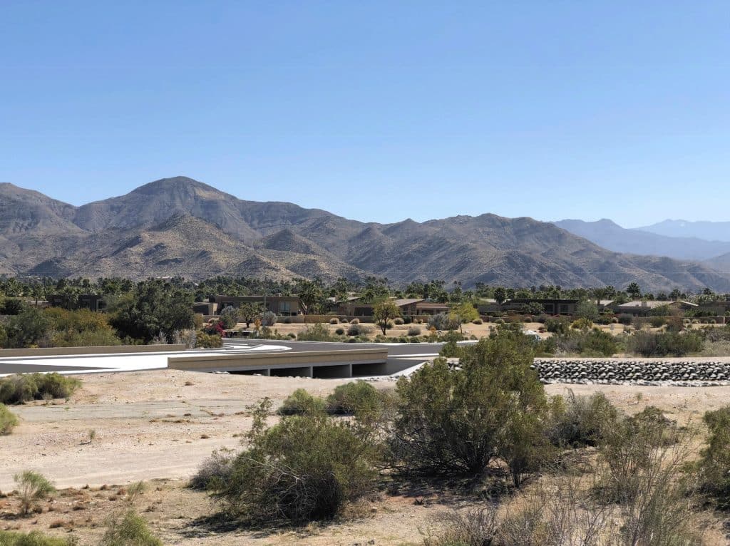
The project, located at South Palm Canyon Drive near East Bogert Trail, has been in development since 2006 and aims to provide flood protection at a crossing that has repeatedly closed during heavy storms.
The Palm Springs City Council voted 3-0 Monday night to approve a $10 million flood control bridge project on South Palm Canyon Drive, rejecting an alternative design proposed by environmental groups and moving forward with a plan nearly 20 years in the making.
The project, located at South Palm Canyon Drive at Arenas Canyon (near East Bogert Trail), has been in development since 2006 and aims to provide flood protection at a crossing that has repeatedly closed during heavy storms, cutting off access to approximately 700 homes in the area.
Local reporting and journalism you can count on.
Subscribe to The Palm Springs Post
The council approved the project with conditions requiring ongoing community engagement and a communication timeline to keep all stakeholders informed throughout the construction process. Councilmember Grace Garner had an excused absence from the meeting and Councilmember David Ready was recused because he lives in the area of the project.
The decision came after nearly an hour of public testimony that highlighted divisions between residents concerned about emergency access and environmental advocates worried about habitat destruction for endangered bighorn sheep. The council heard from 30 speakers, with the majority supporting the city’s proposal and in favor of the project as currently designed.
Community outreach conducted over the past 100 days showed public safety and emergency access was the top concern among residents, with 45% of comments supporting the project, 30% opposed and 25% neutral or seeking clarification.
The council faces a December 2026 deadline to use $4.5 million in federal funding for the project or risk losing the money entirely. The remaining costs will be covered by local gas tax funds, Measure A transportation funds and special development funds collected specifically for drainage improvements in the area.
“This is a critical artery that leads to the south Palm Springs area,” said Mark Waier of Daley Strategies, who conducted community outreach for the city. “There’s 700 homes that have access through this right of way, and last year there were 590 emergency calls from that particular area.”
The project would replace the current roadway with an elevated bridge structure, allowing floodwaters from Oswit Canyon to pass underneath through a rock-lined channel. According to city staff, the alluvial fan can generate runoff of up to 1.3 million gallons per minute during a 100-year storm event.
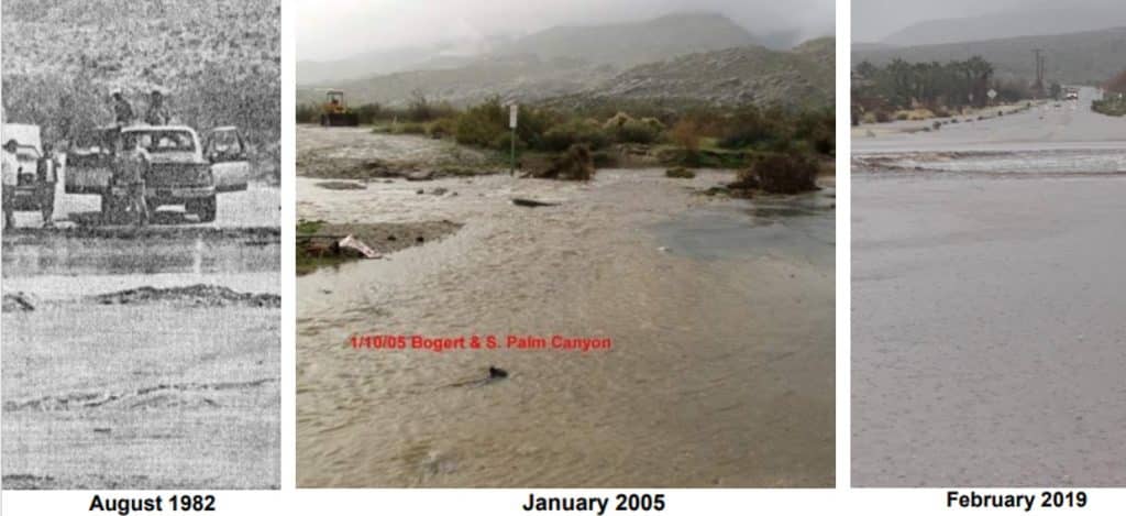
Residents strongly supported the project, citing repeated flooding events that have trapped them in their neighborhoods during emergencies. Karen Miller, who drove through floodwaters during a 2019 Valentine’s Day storm, told the council she feared for her safety.
“The barrier was removed, and we drove through thinking that it was safe. It was not safe. The water came into my car,” Miller said. “The safety of the community is so important and the funding is so very important.”
Palm Springs Fire Chief Paul Alvarado endorsed the project, saying the 2019 Valentine’s Day flood and Tropical Storm Hillary stretched his firefighters “to the limit” providing rescue efforts.
“Important mitigation efforts like the South Palm Canyon bridge can significantly impact that by keeping drivers safe on South Palm Canyon, allowing our firefighters to have access to that neighborhood, and not creating needless rescue efforts in that area,” Alvarado said.
Environmental groups, led by Oswit Land Trust, opposed the city’s design and requested the council wait for completion of updated environmental reviews before proceeding. They expressed concerns about damaging habitat for peninsular bighorn sheep.
The Oswit Land Trust submitted multiple alternative designs, including the most recent which features a flood wall instead of the city’s proposed engineered channel, arguing it would affect less habitat while providing the same flood protection. However, city engineers raised concerns about the alternative’s performance, reliability, timeline and the need for additional property negotiations.
City Engineer Joel Montalvo said the city has already spent over $60,000 in consultant fees and 300 hours reviewing five different alternatives submitted by Oswit over the years, with an additional $100,000 spent on design modifications in 2019-2020 to accommodate earlier environmental concerns.
“We don’t feel comfortable with the fifth alternative. We really want to move forward with our current design, to secure our funding to be able to move forward and construct a bridge in a timely manner,” said Montalvo.
Construction costs have doubled since 2021 due to inflation and project delays caused by litigation. The city has allocated approximately $10 million for the project, with federal funds covering $4.5 million and local sources providing the remainder. The city can also request additional funding from CalTrans.
The council authorized staff to finalize environmental review and complete construction plans for bidding, but added requirements for ongoing community engagement and a communication timeline to keep stakeholders informed of project milestones. The project cannot proceed to construction until a CEQA addendum is completed, expected in August 2025.
Author

Related Articles
Boards meet this week on preservation, sustainability and library issues
A potential historic designation for a downtown synagogue, library trust fund concerns and waste reduction policy are among the items on the agenda.
Commission approves self-storage facility near airport even as city weighs limits on new facilities
A 92,400-square-foot, two-story building with outdoor RV parking won approval Tuesday, while a consulting team examines possible caps and location rules for future projects.
Parks & Recreation Commission approves agreement with newly formed foundation
The agreement, which heads to city council for final approval May 27, outlines a fundraising partnership built around water, shade, and park activation.